Resume
Appointments Calendar · GitHub · LinkedIn · Email craigds89@gmail.com ·
I’m Craig Dsouza - Builder with experience developing and shipping open source SaaS products.
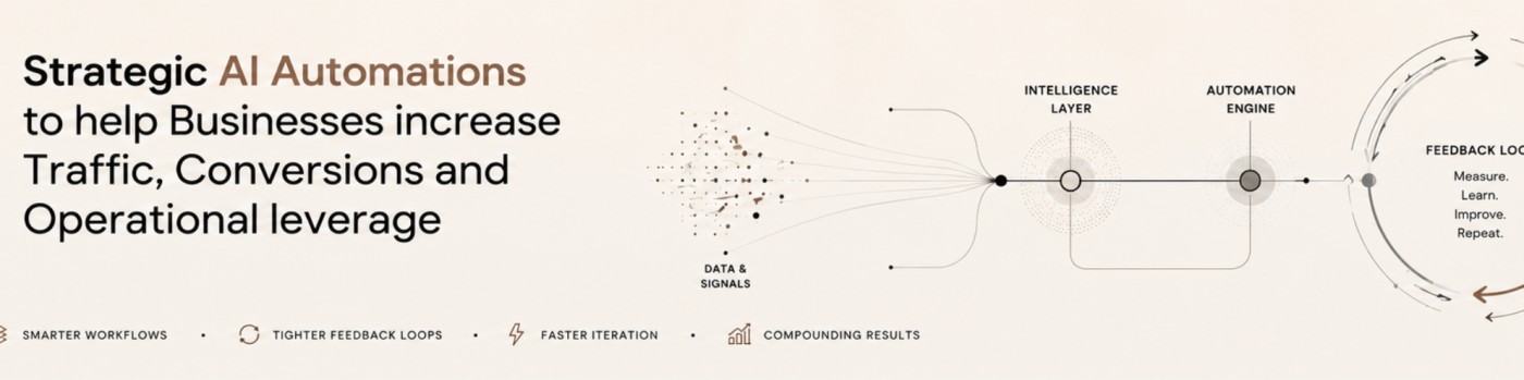
Over the last 3 years, I’ve explored, experimented and built with every major AI tool and framework out there and I’m now helping businesses develop their AI strategy and where necessary with implementation of automations with Claude SDK, OpenAI SDK, LangGraph, n8n, Zapier and more.
I’m motivated by business & technological challenges that when solved improve human well-being. Technically strong software developer, high agency , strong understanding of business processes & AI.
Curious, obsessed with learning and building products that matter.
Career Highlights
Freelance
AI Automations · Jan 2026 - Current
Building and advising businesses on automation with AI.
Water, Environment, Land and Livelihoods (WELL) Labs
Product Manager · Apr 2023 - Dec 2025
Led engineering team to build a scalable geospatial SaaS product for water security monitoring, growing it from concept to 20+ users across six organisations.
Conceptualized, fundraised and executed a campaign to collect drone imagery for a dozen organisations spanning multiple geographies in India, for the purpose of training AI models for crop type mapping and field boundary segmentation.
Ashoka Trust for Research in Ecology and the Environment (ATREE)
Data & Tech Lead · Dec 2020 - Mar 2023
Built data pipelines to facilitate geospatial data access for environmental research at the Centre for Social and Environmental Innovation.
Connected Farms India
Co-Founder · Jul 2019 - Jun 2022
Envisioned, developed and shipped a low-cost IoT groundwater level sensor end-to-end, from hardware design to market, with a team of three.
Watershed Organisation Trust (WOTR)
GIS Consultant · Feb 2021 - Aug 2021
Implemented a Postgres/PostGIS and Google Earth Engine geospatial architecture for plot-scale crop advisory in the Farm Precise App.
INREM Foundation
Monitoring & Evaluation Specialist · Dec 2018 - Dec 2020
Designed statistically valid household surveys and the technical stack for implementation across 5 districts and analysed data to derive insights for a water quality and health programme.
International Water Management Institute (IWMI)
Independent Researcher · Dec 2018 - Dec 2019
Coded remote sensing–based drought indices on the Google Earth Engine cloud platform for agricultural water management research.
Paani Foundation
Project Coordinator / Independent Researcher · Jun 2018 - May 2019
Led the team that built a web app to visualise remote sensing indicators (land use, sown area, soil moisture) across ~100 villages in Maharashtra.
Deep Griha Society
Monitoring & Evaluation Specialist · Jun 2017 - Feb 2020
Built digital data collection and management systems using ODK Collect/Central for impact assessment of development programmes.
Datameet
Independent Researcher & Project Co-ordinator · Jun 2017 - Feb 2018
Led a team of four to build a web app for open access to remotely sensed water data, after raising funding and forming partnerships.
Society for Promoting Participative Ecosystem Management
Research Associate · Nov 2013 - Feb 2017
Developed RS/GIS datasets to track agricultural land use and industrial development, informing civil society water policy debate.
University of Delaware
Graduate Research Associate · Aug 2011 - May 2013
Researched legacy pollutant remediation and urban green infrastructure strategies at the Center for Energy and Environmental Policy.